Life’s Genetic Code Has 5 Key Ingredients. Asteroid Ryugu Has All of Them
Smithsonian Magazine
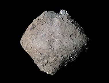
From the article: "The findings further hint that space rocks may have brought the building blocks of RNA and DNA to Earth long ago". Image by Kevin M. Gill, JAXA, displayed here under a Creative Commons License.
Smithsonian Magazine
From the article: "The findings further hint that space rocks may have brought the building blocks of RNA and DNA to Earth long ago". Image by Kevin M. Gill, JAXA, displayed here under a Creative Commons License.
.png)
Watch the Meteor that Shook Cleveland and Soared Over 6+ States
The Weather Channel
Blue sky dashcam videos of the meteor streaking over Ohio and neighboring states that exploded in the atmosphere. The noise and the body sensation produced by the pressure wave gave some people the fright of their life. Plus, see what a meteor looks like on a still dopler radar image.
Pompeii Plaster Casts on Display in a New Museum Exhibition
Smithsonian Magazine
From the article: "The casts preserve residents' final moments before the eruption covered Pompeii in thick layers of ash and volcanic debris, freezing the ancient city in time."
Smithsonian Magazine
From the article: "The casts preserve residents' final moments before the eruption covered Pompeii in thick layers of ash and volcanic debris, freezing the ancient city in time."
Mount Vesuvius: The Volcano that Buried Pompeii
Geology.com
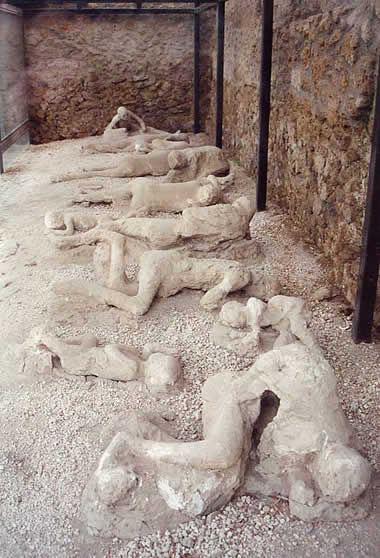
Plaster casts of people who died in the city of Pompeii during the 79 AD eruption of Mount Vesuvius. They were buried in volcanic ash. Image: Garden of the Fugitives. This photo was taken by Lancevortex and is distributed under a GNU Free Documentation License.
Geology.com
Plaster casts of people who died in the city of Pompeii during the 79 AD eruption of Mount Vesuvius. They were buried in volcanic ash. Image: Garden of the Fugitives. This photo was taken by Lancevortex and is distributed under a GNU Free Documentation License.
Mount Vesuvius: All About the Volcano
Geology.com
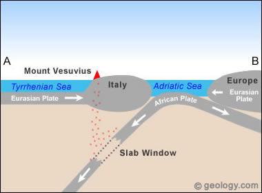
Map showing the location of Mount Vesuvius on the west coast of Italy. Other nearby volcanoes: Etna, Stromboli.
Geology.com
Map showing the location of Mount Vesuvius on the west coast of Italy. Other nearby volcanoes: Etna, Stromboli.
Lake Coatepeque Caldera
NASA Earth Observatory
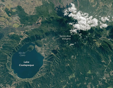
Lake Coatepeque formed during a series of explosive volcanic eruptions between 72,000 and 51,000 years ago. It is located just inland from the Pacific coast of El Salvador. This photo was captured by an astronaut onboard the International Space Station in February, 2026. The link above will take you to an article about the lake and its surrounding landscape. Additional images taken by astronauts and cosmonauts can be viewed at the NASA/JSC Gateway to Astronaut Photography of Earth. Story by Kathryn Hansen.
NASA Earth Observatory
Lake Coatepeque formed during a series of explosive volcanic eruptions between 72,000 and 51,000 years ago. It is located just inland from the Pacific coast of El Salvador. This photo was captured by an astronaut onboard the International Space Station in February, 2026. The link above will take you to an article about the lake and its surrounding landscape. Additional images taken by astronauts and cosmonauts can be viewed at the NASA/JSC Gateway to Astronaut Photography of Earth. Story by Kathryn Hansen.
What is a Caldera? How Do Calderas Form?
Geology.com
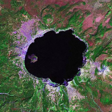
Calderas are some of the most spectacular features on Earth. They are large volcanic craters that form by two different methods: 1) an explosive volcanic eruption; or, 2) collapse of surface rock into an empty magma chamber. The image above is a satellite view of Crater Lake, one of the world's most famous calderas. The image was produced by Angela King of Geology.com using Landsat GeoCover data from NASA.
Geology.com
Calderas are some of the most spectacular features on Earth. They are large volcanic craters that form by two different methods: 1) an explosive volcanic eruption; or, 2) collapse of surface rock into an empty magma chamber. The image above is a satellite view of Crater Lake, one of the world's most famous calderas. The image was produced by Angela King of Geology.com using Landsat GeoCover data from NASA.
Ailing "Megaberg" Sparks Surge of Microscopic Life
NASA Earth Observatory
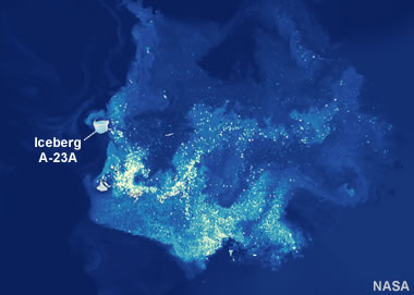
In the false-color image above, plumes of chlorophyll-a are detected in the wake of Iceberg A-23A, shown here just north of South Georgia Island. Chlorophyll concentrations are used to measure the abundance of phytoplankton in the water, and we can conclude that the nutrient-rich meltwater from the iceberg has contributed to a large phytoplankton bloom in the South Atlantic Ocean. NASA Earth Observatory images by Michala Garrison, using VIIRS data from NASA EOSDIS LANCE, GIBS/Worldview, and the Suomi National Polar-orbiting Partnership, PACE data from the NASA Ocean Biology Distributed Active Archive Center OB.DAAC, and Landsat data from the U.S. Geological Survey.
NASA Earth Observatory
In the false-color image above, plumes of chlorophyll-a are detected in the wake of Iceberg A-23A, shown here just north of South Georgia Island. Chlorophyll concentrations are used to measure the abundance of phytoplankton in the water, and we can conclude that the nutrient-rich meltwater from the iceberg has contributed to a large phytoplankton bloom in the South Atlantic Ocean. NASA Earth Observatory images by Michala Garrison, using VIIRS data from NASA EOSDIS LANCE, GIBS/Worldview, and the Suomi National Polar-orbiting Partnership, PACE data from the NASA Ocean Biology Distributed Active Archive Center OB.DAAC, and Landsat data from the U.S. Geological Survey.
Satellite Views of Phytoplankton Blooms in Oceans and Seas
Geology.com
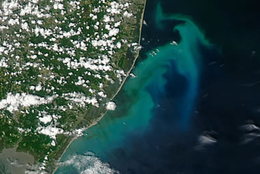
Phytoplankton Bloom Off New Jersey: An unusual phytoplankton bloom occurred in the Atlantic Ocean off the coast of New Jersey on July 6, 2016. This bloom received nutrients from a process known as "upwelling". Strong, persistent winds, blowing off the continent and towards the east, carried surface waters away from the coast. This brought cold, nutrient-rich waters up the continental slope to replace the waters that were blown out to sea. The result was a near-shore phytoplankton bloom. Similar blooms occur periodically along the Atlantic coast in the summer. This NASA satellite image was prepared by Jeff Schmaltz.
Geology.com
Phytoplankton Bloom Off New Jersey: An unusual phytoplankton bloom occurred in the Atlantic Ocean off the coast of New Jersey on July 6, 2016. This bloom received nutrients from a process known as "upwelling". Strong, persistent winds, blowing off the continent and towards the east, carried surface waters away from the coast. This brought cold, nutrient-rich waters up the continental slope to replace the waters that were blown out to sea. The result was a near-shore phytoplankton bloom. Similar blooms occur periodically along the Atlantic coast in the summer. This NASA satellite image was prepared by Jeff Schmaltz.
Scoria Cones on Earth and Mars
NASA Earth Observatory
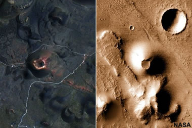
Here we see a side-by-side comparison of the San Francisco Volcanic Field in Arizona, USA, and the Ulysses Colles area in the Tharsis quadrangle of Mars. "Understanding similar features on Earth helps us know what to look for on Mars and interpret processes that we can’t observe directly," said Patrick Whelley, a NASA volcanologist. NASA Earth Observatory images by Lauren Dauphin, using Landsat data from the U.S. Geological Survey and CTX data from the Mars Reconnaissance Orbiter.
NASA Earth Observatory
Here we see a side-by-side comparison of the San Francisco Volcanic Field in Arizona, USA, and the Ulysses Colles area in the Tharsis quadrangle of Mars. "Understanding similar features on Earth helps us know what to look for on Mars and interpret processes that we can’t observe directly," said Patrick Whelley, a NASA volcanologist. NASA Earth Observatory images by Lauren Dauphin, using Landsat data from the U.S. Geological Survey and CTX data from the Mars Reconnaissance Orbiter.
What is Scoria?
Geology.com
Scoria is a dark-colored, vesicular igneous rock that forms from basaltic magmas.
Geology.com
Scoria is a dark-colored, vesicular igneous rock that forms from basaltic magmas.
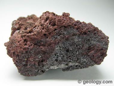
What is a Scoria Cone?
Geology.com

Scoria cones, also called pyroclastic cones or cinder cones, are the simplest and most common type of volcano on Earth. In the image above, Cumbre Vieja Volcano erupts cinders on Spain's Canary Island of La Palma in September 2021.
Geology.com
Scoria cones, also called pyroclastic cones or cinder cones, are the simplest and most common type of volcano on Earth. In the image above, Cumbre Vieja Volcano erupts cinders on Spain's Canary Island of La Palma in September 2021.
Birthstones for the Month of March: Aquamarine and Bloodstone
Geology.com

Aquamarine is a greenish blue to blue variety of the mineral beryl. Compared to other varieties of beryl such as emerald and red beryl, aquamarine gemstones are abundant and affordable.
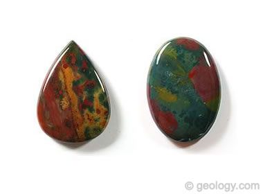
Bloodstone is a green chalcedony with splashes of red. It is sometimes referred to as "heliotrope" in books from the 18th century. It has been used as a birthstone for the month of March since 1912.
Geology.com
Aquamarine is a greenish blue to blue variety of the mineral beryl. Compared to other varieties of beryl such as emerald and red beryl, aquamarine gemstones are abundant and affordable.
Bloodstone is a green chalcedony with splashes of red. It is sometimes referred to as "heliotrope" in books from the 18th century. It has been used as a birthstone for the month of March since 1912.
Total Lunar Eclipse on March 3
NASA
There will be a total lunar eclipse on Tuesday, March 3, 2026. For viewers in the United States, the eclipse will occur during the early morning hours (starting at approximately 1:35 AM PST / 4:35 AM EST). The video above shows the different stages of the eclipse as the moon travels through the Earth's shadow. The times shown in the video are Coordinated Universal Time (UTC), also known as Greenwich Mean Time (GMT). To convert UTC to Eastern Standard Time (EST), subtract 5 hours. To convert UTC to Pacific Standard Time (PST), subtract 8 hours. Video by NASA's Goddard Space Flight Center/Scientific Visualization Studio.
Cloud Seeding: Why More Countries are Turning to Weather Modification
CNBC
The process of "cloud seeding" involves introducing tiny particles of a substance (such as silver iodide) to existing clouds in an effort to induce precipitation. According to the World Meteorological Organization, over 50 countries are experimenting with cloud seeding to alleviate drought, reduce air pollution, or simply control the weather for major events. Article by CNBC. Video by The National News.
Chilled New York City
NASA Earth Observatory
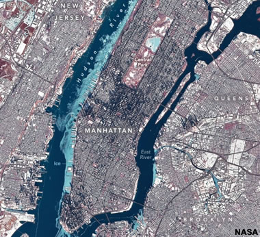
This image shows the large chunks of ice floating in the Hudson River during an extended cold spell in late January. In this false-color image, the ice appears light blue, water appears dark blue, and vegetation appears red. NASA Earth Observatory image by Michala Garrison, using Landsat data from the U.S. Geological Survey.
NASA Earth Observatory
This image shows the large chunks of ice floating in the Hudson River during an extended cold spell in late January. In this false-color image, the ice appears light blue, water appears dark blue, and vegetation appears red. NASA Earth Observatory image by Michala Garrison, using Landsat data from the U.S. Geological Survey.
Showy Swirls Around Jeju Island
NASA Earth Observatory
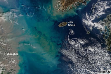
From the article: "Winds blowing past the volcanic landmass near the Korean Peninsula created a trail of spiraling clouds, while murky water churned nearby." NASA Earth Observatory image by Michala Garrison, using MODIS data from NASA EOSDIS LANCE and GIBS/Worldview. Story by Lindsey Doermann.
NASA Earth Observatory
From the article: "Winds blowing past the volcanic landmass near the Korean Peninsula created a trail of spiraling clouds, while murky water churned nearby." NASA Earth Observatory image by Michala Garrison, using MODIS data from NASA EOSDIS LANCE and GIBS/Worldview. Story by Lindsey Doermann.
The Irishman Reviving the Forgotten Sport of Stone Lifting
The Guardian
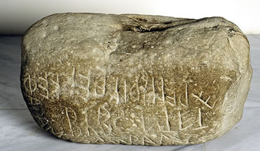
Not an Olympic Sport, but in many parts of the world people participate in an athletic (and mental) activity of lifting very heavy stones. See the Wikipedia article to learn a few of the places where it is practiced. The photo above shows a lifting stone weighing 143 kilograms that is said to have been lifted overhead by Bybon son of Phola in Greece during the early 6th century BC (Image by an unknown photographer, shown here under a Creative Commons license. Learn more at LiftingStones.org
The Guardian
Not an Olympic Sport, but in many parts of the world people participate in an athletic (and mental) activity of lifting very heavy stones. See the Wikipedia article to learn a few of the places where it is practiced. The photo above shows a lifting stone weighing 143 kilograms that is said to have been lifted overhead by Bybon son of Phola in Greece during the early 6th century BC (Image by an unknown photographer, shown here under a Creative Commons license. Learn more at LiftingStones.org
What A Solar Superstorm Could Mean for the United States
United States Geological Survey
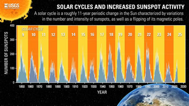
If a geomagnetic storm as large as the famed “Carrington Event” of 1859 were to occur today, it could adversely affect telecommunications and electric power transmission systems across the U.S., especially in the Midwest and the East Coast. About the image: The graphic shows the last 17 solar cycles and their related increased sunspot activity. A solar cycle is a roughly 11-year periodic change in the Sun characterized by variations in the number and intensity of sunspots, as well as a flipping of its magnetic poles.
The table shows the peaks and troughs of solar activity from when measurements began in 1850 until today. Public domain image by the United States Geological Survey.
United States Geological Survey
If a geomagnetic storm as large as the famed “Carrington Event” of 1859 were to occur today, it could adversely affect telecommunications and electric power transmission systems across the U.S., especially in the Midwest and the East Coast. About the image: The graphic shows the last 17 solar cycles and their related increased sunspot activity. A solar cycle is a roughly 11-year periodic change in the Sun characterized by variations in the number and intensity of sunspots, as well as a flipping of its magnetic poles.
The table shows the peaks and troughs of solar activity from when measurements began in 1850 until today. Public domain image by the United States Geological Survey.
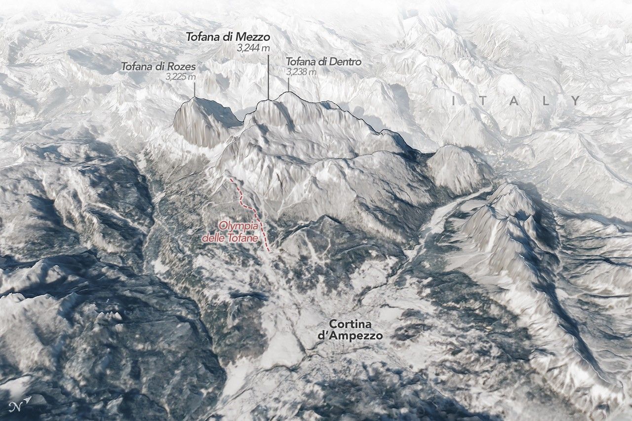
Reaching Top Speed in the Dolomites
NASA

Nestled among high snowy peaks in northern Italy, the city of Cortina d'Ampezzo is hosting athletes in the 2026 Winter Olympics and Paralympics who are skiing, sliding, and curling toward a spot on the podium. The scenic mountain town is the co-host, along with Milan, of the international sporting extravaganza.
Cortina sits within the Dolomites, a mountain range in the northern Italian Alps known for its sheer cliffs, rock pinnacles, tall peaks, and deep, narrow valleys. The three-dimensional oblique map above (click the image to enlarge it), shows the city of Cortina, and to the north, several peaks over 3,000 meters (10,000 feet) tall rise above the town.
The oblique image map above was created by Michala Garrison, using Landsat data from the U.S. Geological Survey and elevation data from TINITALY. Story by Lindsey Doermann. Garrison and Doermann are on the staff of NASA Earth Observatory.
NASA
Nestled among high snowy peaks in northern Italy, the city of Cortina d'Ampezzo is hosting athletes in the 2026 Winter Olympics and Paralympics who are skiing, sliding, and curling toward a spot on the podium. The scenic mountain town is the co-host, along with Milan, of the international sporting extravaganza.
Cortina sits within the Dolomites, a mountain range in the northern Italian Alps known for its sheer cliffs, rock pinnacles, tall peaks, and deep, narrow valleys. The three-dimensional oblique map above (click the image to enlarge it), shows the city of Cortina, and to the north, several peaks over 3,000 meters (10,000 feet) tall rise above the town.
The oblique image map above was created by Michala Garrison, using Landsat data from the U.S. Geological Survey and elevation data from TINITALY. Story by Lindsey Doermann. Garrison and Doermann are on the staff of NASA Earth Observatory.
What Is Dolomite?
Geology.com
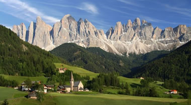
"Dolomite" is a sedimentary rock similar to limestone. It is also known as "dolostone" and "dolomite rock." The gray rocks in the mountain range above are composed mostly of dolomite.
"The Dolomites" are a mountain range in northeastern Italy and part of the Italian Alps. They are one of the largest exposures of dolomite rock on Earth - from which their name is obtained. The Dolomites are a UNESCO World Heritage Site. Image copyright iStockphoto / Dan Breckwoldt.
Geology.com
"Dolomite" is a sedimentary rock similar to limestone. It is also known as "dolostone" and "dolomite rock." The gray rocks in the mountain range above are composed mostly of dolomite.
"The Dolomites" are a mountain range in northeastern Italy and part of the Italian Alps. They are one of the largest exposures of dolomite rock on Earth - from which their name is obtained. The Dolomites are a UNESCO World Heritage Site. Image copyright iStockphoto / Dan Breckwoldt.
New Radar Images from the NISAR Satellite Mission -
A joint mission by NASA and the Indian Space Research Organisation
NASA
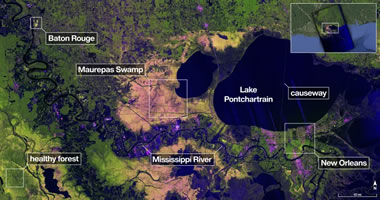
The Joint NISAR project uses a radar instrument that has the ability to "see through cloud cover". They recently produced images of the area around New Orleans, Baton Rouge, Lake Pontchartrain and surrounding wetlands. Click the image above to see a four megabyte view. Image produced by NASA and the Indian Space Research Organisation.
A joint mission by NASA and the Indian Space Research Organisation
NASA
The Joint NISAR project uses a radar instrument that has the ability to "see through cloud cover". They recently produced images of the area around New Orleans, Baton Rouge, Lake Pontchartrain and surrounding wetlands. Click the image above to see a four megabyte view. Image produced by NASA and the Indian Space Research Organisation.
Successful Fund Raising Appeal Helps Buy the Land Around Cerne Abbas Giant
Bournemouth Daily Echo
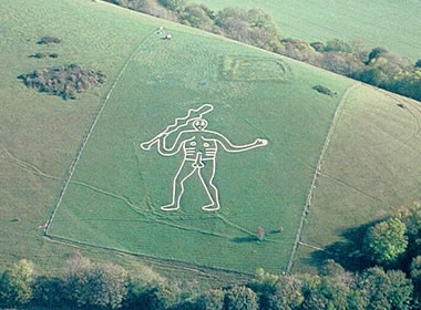
A successful fund-raising appeal helped The National Trust produce approximately £330,000 needed to help purchase the land around the Cerne Abbas Giant Sculpture near Dorset, England. This enormous artwork is thought to have been first carved in the Early Medieval Period (770-1100 AD). It is one of many similar figures carved into the chalky earth in that area. Some consider it to be a landscape-sized petroglyph. Aerial photo taken on 2001-10-07 by Pete Harlow from a Cessna 150 aircraft using a Nikon F70, AF Nikkor 35-80mm on Fujichrome Velvia. Copyright © 2001 Pete Harlow – www.catnip.co.uk This photograph is displayed here under a Creative Commons License.
Bournemouth Daily Echo
A successful fund-raising appeal helped The National Trust produce approximately £330,000 needed to help purchase the land around the Cerne Abbas Giant Sculpture near Dorset, England. This enormous artwork is thought to have been first carved in the Early Medieval Period (770-1100 AD). It is one of many similar figures carved into the chalky earth in that area. Some consider it to be a landscape-sized petroglyph. Aerial photo taken on 2001-10-07 by Pete Harlow from a Cessna 150 aircraft using a Nikon F70, AF Nikkor 35-80mm on Fujichrome Velvia. Copyright © 2001 Pete Harlow – www.catnip.co.uk This photograph is displayed here under a Creative Commons License.
Types of Rock Art: Petroglyphs and Pictographs
Geology.com
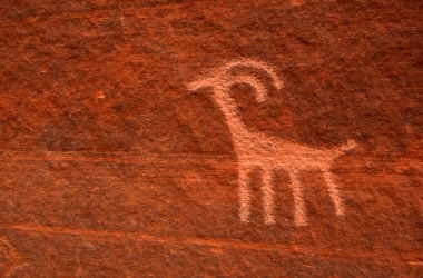
A petroglyph is an image that is carved into a rock. This "carving" can produce a visible indentation in the rock, or it can simply be the scratching away of a weathered surface to reveal unweathered material of a different color below. Image copyright iStockphoto / amygdala_imagery.
A pictograph is a drawing or painting that is created on a rock. It is not "carved" into the rock. Image copyright iStockphoto / Andrea Gingerich.
Geology.com
A petroglyph is an image that is carved into a rock. This "carving" can produce a visible indentation in the rock, or it can simply be the scratching away of a weathered surface to reveal unweathered material of a different color below. Image copyright iStockphoto / amygdala_imagery.
A pictograph is a drawing or painting that is created on a rock. It is not "carved" into the rock. Image copyright iStockphoto / Andrea Gingerich.
USGS Releases Its Annual Mineral Commodity Summaries for 2026
United States Geological Survey
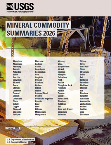
This publication is the first and most authoritative source for mineral production, trade and consumption data. Published by the United States Geological Survey; you can get a PDF online here.
United States Geological Survey
This publication is the first and most authoritative source for mineral production, trade and consumption data. Published by the United States Geological Survey; you can get a PDF online here.
Nevada, Arizona and Texas Are the Top U.S. Mineral Producers for 2025
United States Geological Survey
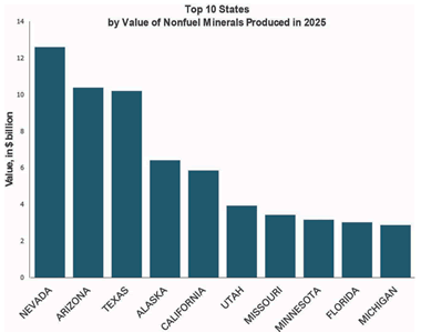
The graph above shows the ten U.S. states with the highest dollar value of non-fuel mineral production. See page 14 and 15 in the Mineral Commodity Summary for a list of the top mineral commodities for each state. Top commodities for Nevada, Arizona and Texas are listed below.
United States Geological Survey
The graph above shows the ten U.S. states with the highest dollar value of non-fuel mineral production. See page 14 and 15 in the Mineral Commodity Summary for a list of the top mineral commodities for each state. Top commodities for Nevada, Arizona and Texas are listed below.
Nevada
produced $12.6 billion dollars worth of copper, diatomite, gold, sand and gravel, silver, and other commodities.Arizona
produced $10.4 billion dollars worth of cement, copper, molybdenum mineral concentrates, sand and gravel, crushed stone, and other commodities.Texas
produced $10.2 billion dollars worth of cement, lime, sand and gravel, industrial sand, and crushed stone.Diatomite: The Rock Used to Make Beer
Geology.com

Diatomite is a rock composed of the siliceous skeletal remains of diatoms. It has a very small particle size, a high porosity, and is relatively inert. That makes it an excellent material for use as a filter. Much of the beer brewed in the United States is filtered through crushed diatomite, known as diatomaceous earth.
Geology.com
Diatomite is a rock composed of the siliceous skeletal remains of diatoms. It has a very small particle size, a high porosity, and is relatively inert. That makes it an excellent material for use as a filter. Much of the beer brewed in the United States is filtered through crushed diatomite, known as diatomaceous earth.
An Asteroid Might Slam Into the Moon in 2032
and Create a Fiery Flash That’s Visible to Earthlings
Smithsonian Magazine
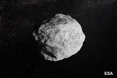
From the article: "Currently, NASA estimates that asteroid 2024 YR4 has a 4.3 percent chance of hitting our lunar companion." The image is an artist's creation of an asteroid - by the European Space Agency Science Office.
and Create a Fiery Flash That’s Visible to Earthlings
Smithsonian Magazine
From the article: "Currently, NASA estimates that asteroid 2024 YR4 has a 4.3 percent chance of hitting our lunar companion." The image is an artist's creation of an asteroid - by the European Space Agency Science Office.
New Earthquake Model Goes Against the Grain
EOS
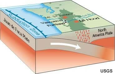
From the article: "Subducting plates are stronger in certain directions than in others, which may be a factor in how earthquakes occur and how seismic waves propagate." Subduction zone image by the United States Geological Survey.
EOS
From the article: "Subducting plates are stronger in certain directions than in others, which may be a factor in how earthquakes occur and how seismic waves propagate." Subduction zone image by the United States Geological Survey.
Record Natural Gas Withdrawals During the Week Ending January 30, 2026
Energy Information Administration
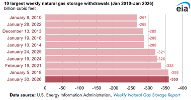
Working natural gas stocks fell 360 billion cubic feet (Bcf) in the Lower 48 states for the week ending January 30, 2026, amid Winter Storm Fern -- the largest weekly net withdrawal reported in the history of the Weekly Natural Gas Storage Report. The withdrawal exceeded the five-year average for the same week by 89% (170 Bcf). The large withdrawals resulted from increased heating demand for natural gas and natural gas production curtailments because of severe winter weather.
Energy Information Administration
Working natural gas stocks fell 360 billion cubic feet (Bcf) in the Lower 48 states for the week ending January 30, 2026, amid Winter Storm Fern -- the largest weekly net withdrawal reported in the history of the Weekly Natural Gas Storage Report. The withdrawal exceeded the five-year average for the same week by 89% (170 Bcf). The large withdrawals resulted from increased heating demand for natural gas and natural gas production curtailments because of severe winter weather.
The Green River Flows ‘Uphill.’ Geologists Think They Finally Know Why.
Popular Science
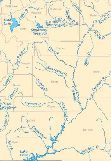
From the article: "An international research team now believes they can explain this longtime mystery behind one of North America’s most prominent river systems. Map shows the confluence of the Green and Colorado Rivers in southeastern Utah. Map by Geology.com.
Popular Science
From the article: "An international research team now believes they can explain this longtime mystery behind one of North America’s most prominent river systems. Map shows the confluence of the Green and Colorado Rivers in southeastern Utah. Map by Geology.com.
Fossils of the Green River Formation
Geology.com
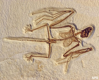
Spectacular fish, animal, plant, insect, and other fossils have been found in the rocks of the Green River Formation in Colorado, Utah and Wyoming. Shown above is a fossilized bat found in the formation. It is the most primitive bat known. Photo by the National Park Service.
Geology.com
Spectacular fish, animal, plant, insect, and other fossils have been found in the rocks of the Green River Formation in Colorado, Utah and Wyoming. Shown above is a fossilized bat found in the formation. It is the most primitive bat known. Photo by the National Park Service.
CIA Ends Publication of its Popular World Factbook Reference Tool
The Associated Press
On February 4, the CIA's website published an announcement that The World Factbook will no longer be available. The sudden termination of this important resource is a huge loss to the millions of people around the world who depend on The World Factbook for reliable maps and information, especially teachers, students, researchers, journalists, and international travelers.
When Is a Sapphire Truly a "Color Change" Sapphire?
Lotus Gemology
Some sapphires change color when exposed to varying wavelengths of light from different light sources. Trace elements in the stone such as Cr, V, or Fe often cause the stone to have different apparent colors under different wavelengths / light sources. Spectacular photo here!
Lotus Gemology
Some sapphires change color when exposed to varying wavelengths of light from different light sources. Trace elements in the stone such as Cr, V, or Fe often cause the stone to have different apparent colors under different wavelengths / light sources. Spectacular photo here!
Dinosaur National Monument Construction Work Turns Up New Fossils
Smithsonian Magazine
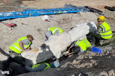
Recent digs revealed roughly 20 feet of a long-necked dinosaur’s skeleton, and paleontologists suspect even more bones are lurking underground. About the photo: "Paleontologists removed roughly 3,000 pounds of rocks and fossils from the site between mid-September and mid-October 2025." National Park Service photo, caption and article by ReBecca Hunt-Foster
Smithsonian Magazine
Recent digs revealed roughly 20 feet of a long-necked dinosaur’s skeleton, and paleontologists suspect even more bones are lurking underground. About the photo: "Paleontologists removed roughly 3,000 pounds of rocks and fossils from the site between mid-September and mid-October 2025." National Park Service photo, caption and article by ReBecca Hunt-Foster
A ‘Very Rare’ Kind of Space Rock Fell in Germany
Smithsonian Magazine
From the article: "Analyses revealed the asteroid was an “aubrite,” a classification that applies to only 80 of 70,000 previously found meteorite fragments."
Smithsonian Magazine
From the article: "Analyses revealed the asteroid was an “aubrite,” a classification that applies to only 80 of 70,000 previously found meteorite fragments."
Cracking Antarctic Sea Ice
NASA Earth Observatory
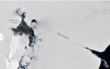
Icebreakers play a critical role in delivering supplies to America's largest research base in Antarctica. In the austral summer, usually in January, an icebreaker rams a path through the fast ice—a type of sea ice that is anchored to the shore—that often covers McMurdo Sound. This annual effort allows cargo ships to reach McMurdo Station, a research base operated by the United States Antarctic Program.
Where Is This Place?
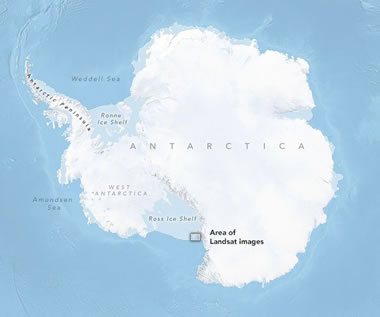
NASA Earth Observatory
Icebreakers play a critical role in delivering supplies to America's largest research base in Antarctica. In the austral summer, usually in January, an icebreaker rams a path through the fast ice—a type of sea ice that is anchored to the shore—that often covers McMurdo Sound. This annual effort allows cargo ships to reach McMurdo Station, a research base operated by the United States Antarctic Program.
Where Is This Place?
Amethyst: Birthstone for February
Geology.com

Amethyst is the purple color variety of quartz. Because it is widely available and inexpensive, amethyst is the world's most popular purple gemstone.
Geology.com
Amethyst is the purple color variety of quartz. Because it is widely available and inexpensive, amethyst is the world's most popular purple gemstone.
Watch the Geographic Fluctuation of Air Temperature for January 21st through January 29th
NOAA

For more information visit NOAA's Extreme January Cold. Following a significant winter storm, frigid temperatures lingered in late January 2026 across a vast swath of the U.S. Watch the cold progress into the Gulf states. Animation by NOAA.
NOAA
For more information visit NOAA's Extreme January Cold. Following a significant winter storm, frigid temperatures lingered in late January 2026 across a vast swath of the U.S. Watch the cold progress into the Gulf states. Animation by NOAA.
As Seas Rise, Corals Can’t Keep Up
EOS

Coral reefs are not growing fast enough to keep up with sea level rise. Photograph of Acropora spp by Jonathan Brown, NOAA Fisheries.
EOS
Coral reefs are not growing fast enough to keep up with sea level rise. Photograph of Acropora spp by Jonathan Brown, NOAA Fisheries.
Jinxiuite: A New Nickel Bismuth Antimony Arsenic Sulfide Mineral Discovered in China
MinDat.org
Geologists from the Chinese Academy of Geological Sciences discovered a new nickel bismuth antimony arsenic sulfide mineral named Jinxiuite at the Longhua Ni-Co deposit, Xiangzhou County, Laibin, Guangxi, China. The mineral has an extraordinary chemical composition of Ni18Bi2SbAsS16.
MinDat.org
Geologists from the Chinese Academy of Geological Sciences discovered a new nickel bismuth antimony arsenic sulfide mineral named Jinxiuite at the Longhua Ni-Co deposit, Xiangzhou County, Laibin, Guangxi, China. The mineral has an extraordinary chemical composition of Ni18Bi2SbAsS16.
World's Deepest Seismometer Braces the South Pole!
United States Geological Survey
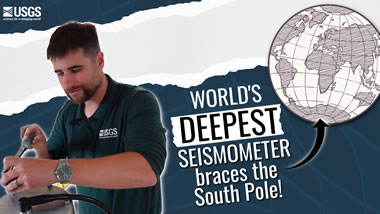
Get ready to journey to the bottom of the world! The Deep Ice Seismometer is a groundbreaking new tool that will revolutionize how we monitor earthquakes across the globe. Why Antarctica? Because it offers the perfect conditions to eliminate noise and distortion, allowing the seismometer to detect even the faintest vibrations from anywhere on Earth.
United States Geological Survey
Get ready to journey to the bottom of the world! The Deep Ice Seismometer is a groundbreaking new tool that will revolutionize how we monitor earthquakes across the globe. Why Antarctica? Because it offers the perfect conditions to eliminate noise and distortion, allowing the seismometer to detect even the faintest vibrations from anywhere on Earth.
Silver Hits $100/ounce, as Gold Nears $5,000/ounce
JCK Online
Two milestones: on Friday, January 23rd, silver broke $100/ounce and gold was only $14 short of $5,000/ounce. These prices are surpassing what almost anyone expected one year ago. Where will these rockets stop?
JCK Online
Two milestones: on Friday, January 23rd, silver broke $100/ounce and gold was only $14 short of $5,000/ounce. These prices are surpassing what almost anyone expected one year ago. Where will these rockets stop?
Lab-Grown Diamonds Are Destroying Economies. Is That Okay?
JCK Online
Botswana, a country in Africa and a leading producer of natural diamonds, is in economic collapse. Their diamond revenues are declining as more diamond shoppers elect to purchase lab-grown diamonds instead of natural diamonds produced from a mine.
JCK Online
Botswana, a country in Africa and a leading producer of natural diamonds, is in economic collapse. Their diamond revenues are declining as more diamond shoppers elect to purchase lab-grown diamonds instead of natural diamonds produced from a mine.
Which Countries Mine the Most Gem-Quality Diamonds?
Geology.com
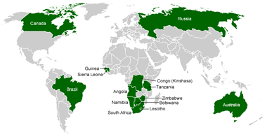
Once centered in Africa, diamond mining now occurs in many countries throughout the world. In recent years, Russia, Canada, and Botswana have been leading producers of mined diamonds.
Geology.com
Once centered in Africa, diamond mining now occurs in many countries throughout the world. In recent years, Russia, Canada, and Botswana have been leading producers of mined diamonds.
"Repatriate the Gold": Economists Advise Withdrawal From U.S. Vaults
The Guardian
Video by the Bank of England, London, where 12% of Germany's gold reserve is stored.
Many German economists, politicians, and government officials are calling for the 1,236 tonnes of German government gold being stored in the United States to be brought home to Germany. Why ?? They don't trust the political environment of the United States.
The United States and Germany are the two countries with the world's highest gold reserves.
The Many Uses of Gold
Geology.com
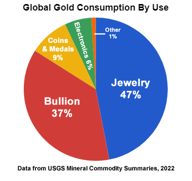
The United States government currently mints coins from gold and other precious metals; however, they are intended for investment and collecting. They are not intended for use as legal tender.
Geology.com
The United States government currently mints coins from gold and other precious metals; however, they are intended for investment and collecting. They are not intended for use as legal tender.
WARNINGS From the National Weather Service: Staying Safe in Extreme Cold
National Weather Service
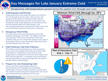
Guidance on dealing with extremely cold weather from the National Weather Service. Please check it out !!
National Weather Service
Guidance on dealing with extremely cold weather from the National Weather Service. Please check it out !!
U.S. Natural Gas Prices Spike in January - WOW !!
U.S. Energy Information Administration
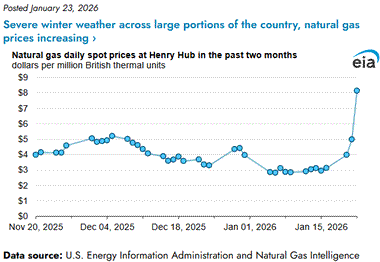
U.S. natural gas prices spiked to nearly $8.15 per million BTU on January 22, 2026 at Henry Hub as severe cold weather across much of the United States caused an enormous spike in demand. Higher natural gas prices generally translate into higher electricity prices - your electric bill that includes the last two weeks of January 2026 might shock you !
U.S. Energy Information Administration
U.S. natural gas prices spiked to nearly $8.15 per million BTU on January 22, 2026 at Henry Hub as severe cold weather across much of the United States caused an enormous spike in demand. Higher natural gas prices generally translate into higher electricity prices - your electric bill that includes the last two weeks of January 2026 might shock you !
Blooming Seas Around the Chatham Islands
NASA Earth Observatory
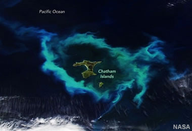
The Chatham Islands are a remote archipelago of islands located about 500 miles east of New Zealand. Phytoplankton blooms are common here because the islands sit atop an underwater plateau called the Chatham Rise, where warm subtropical water mixes with cold, nutrient-rich Antarctic currents. With the summer sunshine facilitating photosynthesis, it is a great environment for phytoplankton to thrive. NASA Earth Observatory image by Lauren Dauphin, using VIIRS data from NASA EOSDIS LANCE, GIBS/Worldview, and the Joint Polar Satellite System (JPSS).
NASA Earth Observatory
The Chatham Islands are a remote archipelago of islands located about 500 miles east of New Zealand. Phytoplankton blooms are common here because the islands sit atop an underwater plateau called the Chatham Rise, where warm subtropical water mixes with cold, nutrient-rich Antarctic currents. With the summer sunshine facilitating photosynthesis, it is a great environment for phytoplankton to thrive. NASA Earth Observatory image by Lauren Dauphin, using VIIRS data from NASA EOSDIS LANCE, GIBS/Worldview, and the Joint Polar Satellite System (JPSS).
Satellite Views of Phytoplankton Blooms in Oceans and Seas
Geology.com
Phytoplankton Bloom Off New Jersey: An unusual phytoplankton bloom occurred in the Atlantic Ocean off the coast of New Jersey on July 6, 2016. This bloom received nutrients from a process known as "upwelling". Strong, persistent winds, blowing off the continent and towards the east, carried surface waters away from the coast. This brought cold, nutrient-rich waters up the continental slope to replace the waters that were blown out to sea. The result was a near-shore phytoplankton bloom. Similar blooms occur periodically along the Atlantic coast in the summer. This NASA satellite image was prepared by Jeff Schmaltz.
Astronomers Find a New Type of Celestial Object
Smithsonian Magazine
From the article: "Named 'Cloud-9,' the discovery is a new type of celestial object known as a RELHIC, that is unlike anything scientists have ever observed." The gas-rich cloud, which is akin to a galaxy without stars, could help astronomers unravel the mysteries of dark matter.
Why Do So Many Mudflows Occur in California?
Associated Press
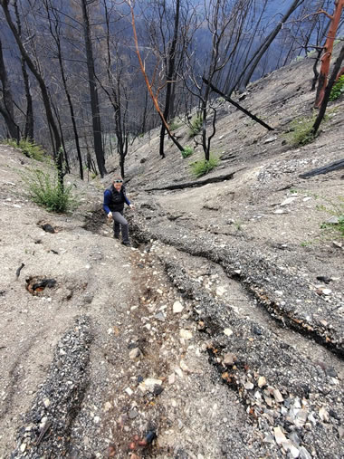
Start with steep slopes covered by hydrophobic soils, denude them of vegetation with a wildfire, and follow up with torrential rains. There you have it! USGS photographer Matt Thomas shot this interesting photo after a wildfire burned through an area near Eagle Rock, California. The land is incredibly steep, there's almost no vegetation to hold the soil in place, and the surface is covered by easily-eroded debris... The perfect recipe for a mudflow.
Associated Press
Start with steep slopes covered by hydrophobic soils, denude them of vegetation with a wildfire, and follow up with torrential rains. There you have it! USGS photographer Matt Thomas shot this interesting photo after a wildfire burned through an area near Eagle Rock, California. The land is incredibly steep, there's almost no vegetation to hold the soil in place, and the surface is covered by easily-eroded debris... The perfect recipe for a mudflow.
Nature Picks the Best Science Images of 2025
Nature
Spectacular copyrighted images of science topics ranging from Villarrica Volcano, to a lab-grown human kidney, to emerald green algae spheres, to red lightning, to a solar-powered slug, and many other subjects that are as colorful as they are interesting.
Nature
Spectacular copyrighted images of science topics ranging from Villarrica Volcano, to a lab-grown human kidney, to emerald green algae spheres, to red lightning, to a solar-powered slug, and many other subjects that are as colorful as they are interesting.
Lessons and Lingering Questions from Collapsing Basaltic Calderas
EOS
From the article: "Research into the hazardous collapses of basaltic volcanoes has revealed common physical processes, but addressing remaining questions requires learning more from historical events."
EOS
From the article: "Research into the hazardous collapses of basaltic volcanoes has revealed common physical processes, but addressing remaining questions requires learning more from historical events."
Amid the Arctic’s Hottest Year, Arctic Science Faces a Data Deficiency
EOS
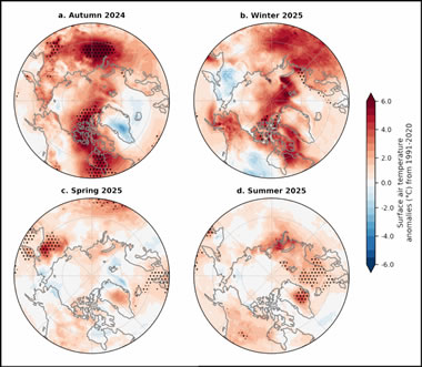
From the article: "The 20th annual Arctic Report Card reveals new highs in temperature and new lows in sea ice, as well as an uncertain outlook for the availability of federal data." The image above shows seasonal surface air temperature anomalies (in °C) for (a) autumn 2024, (b) winter 2025, (c) spring 2025, and (d) summer 2025. Image by NOAA.
EOS
From the article: "The 20th annual Arctic Report Card reveals new highs in temperature and new lows in sea ice, as well as an uncertain outlook for the availability of federal data." The image above shows seasonal surface air temperature anomalies (in °C) for (a) autumn 2024, (b) winter 2025, (c) spring 2025, and (d) summer 2025. Image by NOAA.
USGS Releases Assessment of Undiscovered Oil and Gas in the Woodford and Barnett Shales
United States Geological Survey

The USGS Energy Resources Program is assessing the potential undiscovered oil and gas resources in Texas and New Mexico. Two methodologies are used: one assesses conventional oil and gas resources, and one assesses unconventional (continuous) oil and gas resources (such as shale gas and coalbed gas). Map by USGS.
United States Geological Survey
The USGS Energy Resources Program is assessing the potential undiscovered oil and gas resources in Texas and New Mexico. Two methodologies are used: one assesses conventional oil and gas resources, and one assesses unconventional (continuous) oil and gas resources (such as shale gas and coalbed gas). Map by USGS.
NASA’s Voyager Just Exited the Solar System -- and Found Something Wild
NASA Space News
From the video caption: "NASA’s Voyager spacecraft crossed the heliopause — the boundary where the Sun’s influence ends and interstellar space begins. New data reveal that this region is far more structured and energetic than scientists expected, changing how we understand the true edge of the Solar System."
Petra Diamonds Discovers a 41.82 Carat Blue Diamond
JCK Online
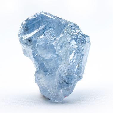
Petra Diamonds has discovered a 41.82-carat blue diamond at its famous Cullinan mine in South Africa. They say it is one of the most important blue diamonds ever found. The image is a photograph of the diamond shared by Petra Diamonds.
JCK Online
Petra Diamonds has discovered a 41.82-carat blue diamond at its famous Cullinan mine in South Africa. They say it is one of the most important blue diamonds ever found. The image is a photograph of the diamond shared by Petra Diamonds.
The Cause of Color in Blue Diamonds
Geology.com
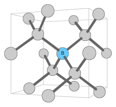
Boron Substitution in Diamond: When boron atoms substitute for carbon atoms in the diamond crystal lattice, it causes the diamond to selectively absorb red wavelengths of light and selectively transmit blue. The blue wavelengths are what reach the eye of the observer. Illustration modified after a Creative Commons image by Materialscientist.
Geology.com
Boron Substitution in Diamond: When boron atoms substitute for carbon atoms in the diamond crystal lattice, it causes the diamond to selectively absorb red wavelengths of light and selectively transmit blue. The blue wavelengths are what reach the eye of the observer. Illustration modified after a Creative Commons image by Materialscientist.
Freedom from China? The Mine at the Centre of Europe’s Push for Rare Earth Metals
The Guardian
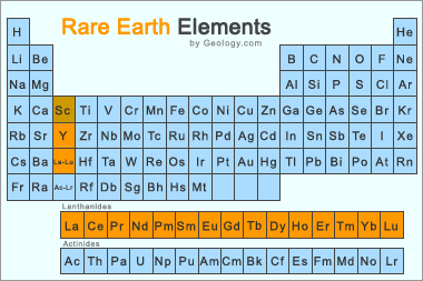
From the article: "Swedish producer is trying to accelerate the process of extracting the elements vital for hi-tech products." Image: The Rare Earth Periodic Table: The Rare Earth Elements are the 15 lanthanide series elements, plus yttrium. Scandium is found in most rare earth element deposits and is sometimes classified as a rare earth element. Image by Geology.com.
The Guardian
From the article: "Swedish producer is trying to accelerate the process of extracting the elements vital for hi-tech products." Image: The Rare Earth Periodic Table: The Rare Earth Elements are the 15 lanthanide series elements, plus yttrium. Scandium is found in most rare earth element deposits and is sometimes classified as a rare earth element. Image by Geology.com.
Rare Earth Element Production is Up... China Is Still the Big Producer
Geology.com

This chart shows a history of rare earth element production, in metric tons of rare earth oxide equivalent, between 1950 and 2024. It clearly shows the United States' entry into the market in the mid-1960s when color television exploded demand. When China began selling rare earths at very low prices in the late 1980s and early 1990s, mines in the United States were forced to close because... read the full caption and article.
Geology.com
This chart shows a history of rare earth element production, in metric tons of rare earth oxide equivalent, between 1950 and 2024. It clearly shows the United States' entry into the market in the mid-1960s when color television exploded demand. When China began selling rare earths at very low prices in the late 1980s and early 1990s, mines in the United States were forced to close because... read the full caption and article.
15 Awesome Images From One of the World’s Most Impressive Aerial Photographers
Smithsonian Magazine
From the article: "From the cockpit of his plane, photographer Jassen Todorov’s eagle eye captures memorable landscapes"
Smithsonian Magazine
From the article: "From the cockpit of his plane, photographer Jassen Todorov’s eagle eye captures memorable landscapes"
January Birthstone: Garnet, A Mineral (and Gemstone) of Many Colors
Geology.com

Gem Garnets: When most people think of garnet, they think of a red gemstone. However, garnet is a mineral which occurs in a wide variety of colors. Clockwise from the top left: red almandine (Madagascar), green tsavorite (Tanzania), yellow mali (Mali), orange spessartite (Mozambique), pink malaya (Tanzania), green merelani mint (Tanzania), red pyrope (Cote d'Ivoire), green demantoid (Namibia), purple rhodolite (Mozambique), and orange hessonite (Sri Lanka).
Geology.com
Gem Garnets: When most people think of garnet, they think of a red gemstone. However, garnet is a mineral which occurs in a wide variety of colors. Clockwise from the top left: red almandine (Madagascar), green tsavorite (Tanzania), yellow mali (Mali), orange spessartite (Mozambique), pink malaya (Tanzania), green merelani mint (Tanzania), red pyrope (Cote d'Ivoire), green demantoid (Namibia), purple rhodolite (Mozambique), and orange hessonite (Sri Lanka).
25 Years of Chocolate Diamonds: Le Vian Marks a Jewelry Milestone
JCK Online
The name "Chocolate Diamonds®" is a registered trademark of Le Vian, a family-owned jewelry company with a long history dating back to the 15th century. In the early 2000s, Le Vian started using the name Chocolate Diamonds® for diamonds that graded to a limited range of brown hues - carefully chosen to register "chocolate" in a shopper's eye. The name was descriptive, fun, and became very popular. It elevated common brown diamonds to a new and special plane of desirability. Take a look at the diamonds shown in this article and see for yourself.
Maduro's Capture in Oil-Rich Venezuela Will Not Drop U.S. Gasoline Prices Any Time Soon
CNBC Oil and Gas
Although the United States says it is going to take over Venezuela's oil and gas industry, imports from Venezuela into the U.S. will not lower U.S. gasoline prices right away. Why? 1) Venezuela currently produces less than a million barrels per day, 2) the country's oil & gas infrastructure is in terrible condition, and, 3) ramping up production will take years.
A Siberian Snowman in Billings (Siberia)
NASA Earth Observatory

Icons of winter are sometimes found in unexpected places. In one striking example, a series of oval lagoons in a remote part of Siberia forms the shape of a towering snowman when viewed from above. NASA Earth Observatory image by Michala Garrison, using Landsat data from USGS. Story by Adam Voiland.
NASA Earth Observatory
Icons of winter are sometimes found in unexpected places. In one striking example, a series of oval lagoons in a remote part of Siberia forms the shape of a towering snowman when viewed from above. NASA Earth Observatory image by Michala Garrison, using Landsat data from USGS. Story by Adam Voiland.
Lake Eyre Blushes
NASA Earth Observatory
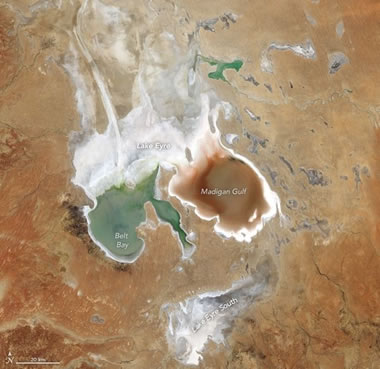
Rounding out a remarkable year, the outback lake displayed distinct green and reddish water in its two main bays. NASA Earth Observatory image by Lauren Dauphin, using Landsat data from USGS. Story by Lindsey Doermann.
NASA Earth Observatory
Rounding out a remarkable year, the outback lake displayed distinct green and reddish water in its two main bays. NASA Earth Observatory image by Lauren Dauphin, using Landsat data from USGS. Story by Lindsey Doermann.
Don’t Miss These Ten Celestial Events in 2026, From Aligned Planets to a Total Solar Eclipse
Smithsonian Magazine

Mark your 2026 Calendar to make sure that you don't miss your favorite events. The "progression of a solar eclipse" image displayed above is a public domain image created by Keegan Barber of NASA.


Get free printable calendars, graph paper, targets and outline maps at our WaterproofPaper.com website.
Smithsonian Magazine
Mark your 2026 Calendar to make sure that you don't miss your favorite events. The "progression of a solar eclipse" image displayed above is a public domain image created by Keegan Barber of NASA.
Get free printable calendars, graph paper, targets and outline maps at our WaterproofPaper.com website.
USGS National Water Dashboard ** Highly Recommended **
United States Geological Survey

The USGS National Water Dashboard is an interactive U.S. map with lots of useful water and weather data. You can find real-time stream gage data, current and forecasted weather and hazard conditions, alerts for flooding, fire, air quality, and more. The base map is customizable to show topographic information, roads and streets, or satellite imagery. Check it out!
United States Geological Survey
The USGS National Water Dashboard is an interactive U.S. map with lots of useful water and weather data. You can find real-time stream gage data, current and forecasted weather and hazard conditions, alerts for flooding, fire, air quality, and more. The base map is customizable to show topographic information, roads and streets, or satellite imagery. Check it out!
Australia Energy Report
Energy Information Administration

Fossil fuels accounted for almost 98% of Australia's primary energy production. A large producer of both natural gas and coal, Australia is a net exporter of energy. Around two-thirds of Australia's production is exported. More information on the article page.
Energy Information Administration
Fossil fuels accounted for almost 98% of Australia's primary energy production. A large producer of both natural gas and coal, Australia is a net exporter of energy. Around two-thirds of Australia's production is exported. More information on the article page.
Lab-Grown Diamonds Are "Mainstream." Now What?
JCK Oline

Now the sector's marketing must evolve so they're seen less as a natural diamond substitute and more as a distinct product.
JCK Oline
Now the sector's marketing must evolve so they're seen less as a natural diamond substitute and more as a distinct product.
What Lies Beneath Greenland Could Change What We Know About Rising Seas
Phys.org
A new study by the University of Ottawa provides a series of detailed 3D models of the Earth's temperature beneath Greenland and northeastern Canada, providing insights into the region's geological history and the response of the ice sheet to past and future climate change.
Phys.org
A new study by the University of Ottawa provides a series of detailed 3D models of the Earth's temperature beneath Greenland and northeastern Canada, providing insights into the region's geological history and the response of the ice sheet to past and future climate change.
Are These 400,000-Year-Old Rock Fragments the Oldest Evidence of Human Fire-Making?
Smithsonian Magazine
Could These 400,000-Year-Old Rock Fragments Be the Oldest Known Evidence of Human Fire-Making?
Smithsonian Magazine
Could These 400,000-Year-Old Rock Fragments Be the Oldest Known Evidence of Human Fire-Making?
This Lemon-Shaped Planet Has an Atmosphere Unlike Anything Astronomers Have Ever Seen
Smithsonian Magazine

The James Webb Space Telescope detected an atmosphere rich with carbon and helium, which is unexpected on this hot planet roughly 2,000 light-years from Earth. The image is in the public domain and is attributed to NASA, ESA, CSA, Ralf Crawford (STScI).
Smithsonian Magazine
The James Webb Space Telescope detected an atmosphere rich with carbon and helium, which is unexpected on this hot planet roughly 2,000 light-years from Earth. The image is in the public domain and is attributed to NASA, ESA, CSA, Ralf Crawford (STScI).
Lessons and Lingering Questions from Collapsing Basaltic Calderas
EOS
From the article: "Research into the hazardous collapses of basaltic volcanoes has revealed common physical processes, but addressing remaining questions requires learning more from historical events." The video is by IRIS Earthquake Science.
EOS
From the article: "Research into the hazardous collapses of basaltic volcanoes has revealed common physical processes, but addressing remaining questions requires learning more from historical events." The video is by IRIS Earthquake Science.
New Eyes on One of the Planet’s Largest Submarine Landslides
EOS
The Stad Slide is a seafloor megaslide that occurred beneath the Norwegian Sea, between Norway and Greenland. It is estimated to be several hundred thousand years old. Researchers are working to determine if it produced a tsunami.
EOS
The Stad Slide is a seafloor megaslide that occurred beneath the Norwegian Sea, between Norway and Greenland. It is estimated to be several hundred thousand years old. Researchers are working to determine if it produced a tsunami.
Strawberry Quartz
Geology.com

"Strawberry quartz" is a novelty gem and a marketing term used for specimens of pink to red quartz or quartzite that receive their color from eye-visible mineral inclusions. The photo shows a collection of beautiful strawberry quartz cabochons in a range of pink to red colors. The intensity of red color is related to the number of red mineral inclusions and their distribution within the stone. Photograph by Urvi Agrawal, owner of the GemsForJewels Etsy Store.
Geology.com
"Strawberry quartz" is a novelty gem and a marketing term used for specimens of pink to red quartz or quartzite that receive their color from eye-visible mineral inclusions. The photo shows a collection of beautiful strawberry quartz cabochons in a range of pink to red colors. The intensity of red color is related to the number of red mineral inclusions and their distribution within the stone. Photograph by Urvi Agrawal, owner of the GemsForJewels Etsy Store.
California Rain May Ease But More Mudslides, Flooding Possible (Video)
CBS News
A risk of high surf along the coast, flash flooding near Los Angeles and avalanches in the Sierra Nevada remain.
CBS News
A risk of high surf along the coast, flash flooding near Los Angeles and avalanches in the Sierra Nevada remain.
USGS Assessment of Undiscovered Gas Resources in the Haynesville Formation
United States Geological Survey

Using a geology-based assessment methodology, the U.S. Geological Survey estimated undiscovered, technically recoverable mean resources of 152 million barrels of oil and 47.9 trillion cubic feet of gas in reservoirs of the Haynesville Formation within the onshore United States and State waters of the Gulf Coast Basin. Public domain map by the U.S. Geological Survey.
United States Geological Survey
Using a geology-based assessment methodology, the U.S. Geological Survey estimated undiscovered, technically recoverable mean resources of 152 million barrels of oil and 47.9 trillion cubic feet of gas in reservoirs of the Haynesville Formation within the onshore United States and State waters of the Gulf Coast Basin. Public domain map by the U.S. Geological Survey.
Flood Threat For Southern California As Atmospheric Rivers Target The State
The Weather Channel
Heavy rain has caused flash flooding and landslides in Southern California between December 23 and December 25.
The Weather Channel
Heavy rain has caused flash flooding and landslides in Southern California between December 23 and December 25.
USGS Assessment of Undiscovered Oil and Gas Under Santa Barbara County, California
United States Geological Survey

From the article: "The U.S. Geological Survey released its assessment of potential for undiscovered oil and gas in formations under the Santa Maria Basin geologic province under Santa Barbara County and part of San Luis Obispo County, California, assessing that there are technically recoverable resources of 67 million barrels of oil and 56 billion cubic feet of gas."
United States Geological Survey
From the article: "The U.S. Geological Survey released its assessment of potential for undiscovered oil and gas in formations under the Santa Maria Basin geologic province under Santa Barbara County and part of San Luis Obispo County, California, assessing that there are technically recoverable resources of 67 million barrels of oil and 56 billion cubic feet of gas."
EU Diamond Importers Must Do More Russian Diligence
JCKOnline
The European Union is tightening their import standards to reduce the number of Russian diamonds that are imported illegally. Now importers must attest to the statement below (and more):
"I, the undersigned, hereby declare that the non-industrial, natural, polished diamonds in this shipment were not mined, extracted, produced, or manufactured wholly or in part in the Russian Federation, notwithstanding whether such diamonds have been substantially transformed into other products outside of the Russian Federation."
Satellite Monitoring of Seasonal Pulses in Earth’s Glaciers
NASA Earth Observatory

From Alaska’s Saint Elias Mountains to Pakistan’s Karakoram, glaciers speed up and slow down with the seasons. The image is a view of the Baltoro and neighboring glaciers in Alaska. Red areas on the glaciers showed signs of movement when the image was captured (visit the article to see larger animated images). Images by Chad Greene and Alex Gardner, using data from the NASA MEaSUREs project ITS_LIVE. Story by Kathryn Hansen.
NASA Earth Observatory
From Alaska’s Saint Elias Mountains to Pakistan’s Karakoram, glaciers speed up and slow down with the seasons. The image is a view of the Baltoro and neighboring glaciers in Alaska. Red areas on the glaciers showed signs of movement when the image was captured (visit the article to see larger animated images). Images by Chad Greene and Alex Gardner, using data from the NASA MEaSUREs project ITS_LIVE. Story by Kathryn Hansen.
The Arctic Is the Hottest It's Been in 125 Years of Record-Keeping
NBC News
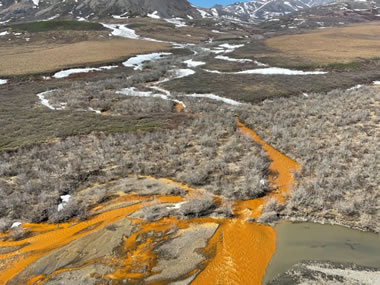
Iron released from melting permafrost in Arctic Alaska is giving many streams an orange color. The photograph shows an orange tributary of the Kugororuk River in the Brooks Range of Northern Alaska. The photo is by Josh Koch, a USGS staff member, and is displayed here as a public domain image.
NBC News
Iron released from melting permafrost in Arctic Alaska is giving many streams an orange color. The photograph shows an orange tributary of the Kugororuk River in the Brooks Range of Northern Alaska. The photo is by Josh Koch, a USGS staff member, and is displayed here as a public domain image.
From Black Shales to Drinking Water: What Groundwater Chemistry Tells Us
Speaking of Geoscience Blog
The author is Fidelis Onwuagba, a 2023 recipient of a Graduate Student Research Grant.
Speaking of Geoscience Blog
The author is Fidelis Onwuagba, a 2023 recipient of a Graduate Student Research Grant.
When Did People First Arrive in Australasia?
The Conversation

A new archaeogenetics study dates it to 60,000 years ago.
The Conversation
A new archaeogenetics study dates it to 60,000 years ago.
Ekati Diamond Mine Gets $115M Federal Loan, Avoids Bankruptcy
CBC - Radio Canada
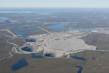
Ekati is the name of the first diamond mine developed in the Northwest Territories of Canada in 1991. It was profitably worked for over 30 years but is currently facing bankruptcy. A loan from the Canadian government will put it back into operation and enable it to survive. The image is a low-angle aerial photograph of the open pit mine from 2010 showing three pits. The photo is by Jason Pineau and is displayed here under a Creative Commons License.
CBC - Radio Canada
Ekati is the name of the first diamond mine developed in the Northwest Territories of Canada in 1991. It was profitably worked for over 30 years but is currently facing bankruptcy. A loan from the Canadian government will put it back into operation and enable it to survive. The image is a low-angle aerial photograph of the open pit mine from 2010 showing three pits. The photo is by Jason Pineau and is displayed here under a Creative Commons License.
Diamond Mines in Canada
Geology.com
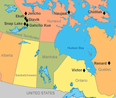
A map of Canadian diamond mines showing the approximate location of eight mines. Since producing its first commercial diamond in 1998, Canada has become one of the world's most important producers of gem-quality diamonds. Map by Geology.com and MapResources.
Geology.com
A map of Canadian diamond mines showing the approximate location of eight mines. Since producing its first commercial diamond in 1998, Canada has become one of the world's most important producers of gem-quality diamonds. Map by Geology.com and MapResources.
Get a Glimpse Inside the Life of a Doomsday Asteroid Hunter
Smithsonian Magazine
"David Rankin of the Catalina Sky Survey in Arizona spends nights scanning the solar system for potentially catastrophic space rocks. Here's what he has to say about that 'high consequence' work, an interstellar comet and living with uncertainty."
Smithsonian Magazine
"David Rankin of the Catalina Sky Survey in Arizona spends nights scanning the solar system for potentially catastrophic space rocks. Here's what he has to say about that 'high consequence' work, an interstellar comet and living with uncertainty."
Birthstones for the Month of December: Turquoise, Zircon, and Tanzanite
Geology.com
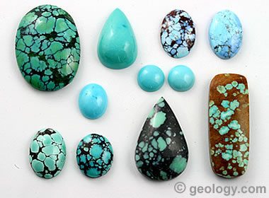
Turquoise is a traditional birthstone for the month of December.
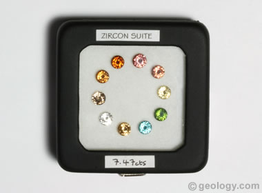
Zircon replaced lapis lazuli as a modern birthstone in 1952.
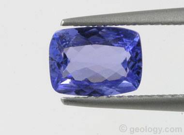
Tanzanite became the newest birthstone for the month of December when it was added in 2002.
Geology.com
Turquoise is a traditional birthstone for the month of December.
Zircon replaced lapis lazuli as a modern birthstone in 1952.
Tanzanite became the newest birthstone for the month of December when it was added in 2002.
A Giant Structure Deep Beneath Bermuda Is Unlike Anything Else on Earth
LiveScience.com

From the article: "A thick layer of more than 12 miles of rock may explain why Bermuda seems to float above the surrounding ocean."
LiveScience.com
From the article: "A thick layer of more than 12 miles of rock may explain why Bermuda seems to float above the surrounding ocean."
When Should a Tsunami Not Be Called a Tsunami?
EOS
From the article: "It’s time to redefine the term so it more clearly conveys meaningful risks to coastal communities and prompts them to act when needed."
EOS
From the article: "It’s time to redefine the term so it more clearly conveys meaningful risks to coastal communities and prompts them to act when needed."
When Does Rainfall Become Recharge?
EOS
From the article: "Counting drips in caves is helping to reveal how much precipitation is needed to start refilling underground aquifers."
EOS
From the article: "Counting drips in caves is helping to reveal how much precipitation is needed to start refilling underground aquifers."
Modern Humans Reached Australia Around 60,000 Years Ago via Two Routes, Genetic Analysis Suggests
Smithsonian Magazine

The study bolsters one hypothesis of when people arrived at the landmass that became Australia and other islands, and presents some of the earliest evidence of seafaring. Map by Helen Farr and Erich Fisher displayed here under a creative commons license.
Smithsonian Magazine
The study bolsters one hypothesis of when people arrived at the landmass that became Australia and other islands, and presents some of the earliest evidence of seafaring. Map by Helen Farr and Erich Fisher displayed here under a creative commons license.
Newly Revealed Secrets About the 2,000-Year-Old Recipe for Roman Concrete
Smithsonian Magazine
The Romans’ hot-mixing method entailed blending volcanic ash and other dry ingredients with “quicklime,” a form of highly reactive, dry limestone. Adding water set off a chain reaction that produced heat—hence the name.
Smithsonian Magazine
The Romans’ hot-mixing method entailed blending volcanic ash and other dry ingredients with “quicklime,” a form of highly reactive, dry limestone. Adding water set off a chain reaction that produced heat—hence the name.
NASA Detects a Thick Atmosphere Around a Broiling Lava World
NASA

The image shows an artist's concept of a "Super-Earth Exoplanet TOI-561 b" (right) and its star (left). The exoplanet is thought be covered by a magma ocean, surrounded by a thick atmosphere, and have a density that is much lower than expected.
NASA
The image shows an artist's concept of a "Super-Earth Exoplanet TOI-561 b" (right) and its star (left). The exoplanet is thought be covered by a magma ocean, surrounded by a thick atmosphere, and have a density that is much lower than expected.
98% of Gaza’s Tree Cropland Destroyed by Israel
EOS
From the article: "Maps based on remote sensing analysis could inform remediation efforts by identifying whether agricultural lands were damaged by bombs, debris, or forced displacement of its caretakers."
EOS
From the article: "Maps based on remote sensing analysis could inform remediation efforts by identifying whether agricultural lands were damaged by bombs, debris, or forced displacement of its caretakers."
A New Era of Floods Has Arrived. America Isn’t Prepared.
The Washington Post
A Washington Post investigation reveals why so few people evacuated in the state hit hardest by last year’s deadliest disaster.
The Washington Post
A Washington Post investigation reveals why so few people evacuated in the state hit hardest by last year’s deadliest disaster.
This Site in Bolivia Boasts 16,600 Exposed Dinosaur Footprints --
The Most Ever Found in One Location
Smithsonian Magazine
From the article: "Millions of years ago, dinosaurs hightailed their way across what is now a national park in Bolivia."
The Most Ever Found in One Location
Smithsonian Magazine
From the article: "Millions of years ago, dinosaurs hightailed their way across what is now a national park in Bolivia."
Archaeologists Are Unraveling the Mysteries Behind Deep Pits Found Near Stonehenge
Smithsonian Magazine
From the article: "Based on a comprehensive study, researchers are now convinced the shafts were human-made, likely dug during the Late Neolithic period roughly 4,000 years ago."
Smithsonian Magazine
From the article: "Based on a comprehensive study, researchers are now convinced the shafts were human-made, likely dug during the Late Neolithic period roughly 4,000 years ago."
Stonehenge: A Monument Made of a Unique Diabase
Geology.com
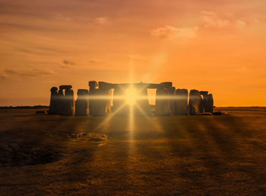
Sunrise at Stonehenge: The standing stones at Stonehenge were placed to be in alignment with sunset on the winter solstice and sunrise on the summer solstice. Photograph copyright iStockphoto / Stephen Barnes.
Geology.com
Sunrise at Stonehenge: The standing stones at Stonehenge were placed to be in alignment with sunset on the winter solstice and sunrise on the summer solstice. Photograph copyright iStockphoto / Stephen Barnes.
The Land Beneath Antarctica’s Ice Might Be Full of Water
EOS
Quote from the article: "Now, using an array of seismic sensors, researchers from Stony Brook University have added more data points to the map of subglacial Antarctica, finding evidence of a layer of water-saturated sediments or rock under the ice."
EOS
Quote from the article: "Now, using an array of seismic sensors, researchers from Stony Brook University have added more data points to the map of subglacial Antarctica, finding evidence of a layer of water-saturated sediments or rock under the ice."
Massive Groundwater Systems Lie Beneath Antarctic Ice
From the EOS Archive - June 2022
From the article: Researchers from "Scripps Institution of Oceanography, have confirmed scientific suspicions, uncovering significant groundwater amid sediment below ice sheets in Whillans Ice Stream in Antarctica."
From the EOS Archive - June 2022
From the article: Researchers from "Scripps Institution of Oceanography, have confirmed scientific suspicions, uncovering significant groundwater amid sediment below ice sheets in Whillans Ice Stream in Antarctica."
Planet-Eating Stars Hint at Earth's Ultimate Fate
EOS

After a star exhausts its hydrogen nuclear fuel, its diameter expands more than a hundredfold, engulfing any unlucky planets in close orbits. The image is an artist's impression of an ultra-hot exoplanet, a planet beyond our Solar System, as it is about to transit in front of its host star. Image created by the European Southern Observatory and displayed here under a Creative Commons license. More information about the image and its license can be found here.
EOS
After a star exhausts its hydrogen nuclear fuel, its diameter expands more than a hundredfold, engulfing any unlucky planets in close orbits. The image is an artist's impression of an ultra-hot exoplanet, a planet beyond our Solar System, as it is about to transit in front of its host star. Image created by the European Southern Observatory and displayed here under a Creative Commons license. More information about the image and its license can be found here.
USGS Updates on Eruption at Kilauea Crater
United States Geological Survey
Links to videos, photos, maps and more related to the early December eruptions at Kilauea.
United States Geological Survey
Links to videos, photos, maps and more related to the early December eruptions at Kilauea.
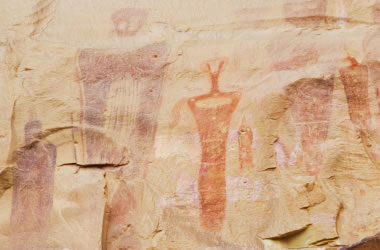
Researchers Discover the Shocking Age of the Mysterious Pecos River Rock Art
Smithsonian Magazine
The murals were painted on limestone canyon walls, in the same style, over the span of four millennia.
Smithsonian Magazine
The murals were painted on limestone canyon walls, in the same style, over the span of four millennia.
Archaeologists Say: Conch Shells May Have Been Used to Make Music 6,000 Years Ago
Smithsonian Magazine
From the article: New research suggests that a collection of conch shells unearthed in Spain may have once produced melodies, in addition to enabling communication across long distances.
Smithsonian Magazine
From the article: New research suggests that a collection of conch shells unearthed in Spain may have once produced melodies, in addition to enabling communication across long distances.
Ethiopian Volcano Erupts for the First Time in Recorded History
Smithsonian Magazine
In northern Ethiopia, the Hayli Gubbi volcano has erupted for the first time in recorded history - or at least, it is the first recorded eruption in history. The shield volcano expelled a large ash plume, which drifted over 2,200 miles into Asia, blanketing villages in volcanic ash and affecting air travel. Hayli Gubbi is located in the Afar Depression, which is part of the East African Rift System.
East Africa's Great Rift Valley: A Complex Rift System
Geology.com
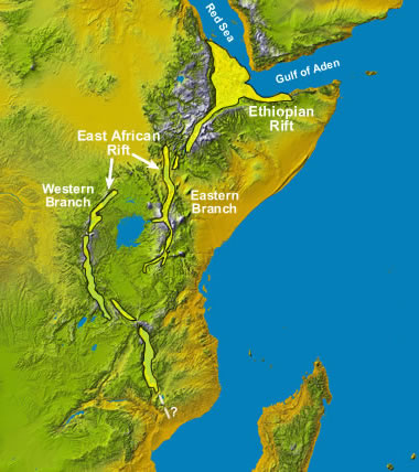
The image above shows the segments of the East African Rift System. The basemap is a Space Shuttle radar topography image by NASA.
Geology.com
The image above shows the segments of the East African Rift System. The basemap is a Space Shuttle radar topography image by NASA.
Volcanic Ash - The Product of a Volcano that is Often Underestimated
Geology.com
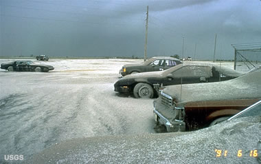
Volcanic ash on cars at Clark Air Base in the Philippines after the 1991 eruption of Mount Pinatubo. This parking lot is about 25 kilometers east of the eruption and received about 9 centimeters of ash. USGS image by R.P. Hoblitt.
Geology.com
Volcanic ash on cars at Clark Air Base in the Philippines after the 1991 eruption of Mount Pinatubo. This parking lot is about 25 kilometers east of the eruption and received about 9 centimeters of ash. USGS image by R.P. Hoblitt.
Deep Groundwater Might Be a Sustainable Solution to the Water Crisis
EOS
From the article: Scientists are finding fresh groundwater buried deep underground, but questions remain about the scale of these resources, how they're resupplied, and whether they can be used sustainably.
EOS
From the article: Scientists are finding fresh groundwater buried deep underground, but questions remain about the scale of these resources, how they're resupplied, and whether they can be used sustainably.
Self-Guided Walking Tour: Three Rivers Petroglyph Site
Bureau of Land Management

The petroglyphs (rock carvings) were made by prehistoric Native Americans that archaeologists refer to as the Jornada Mogollon. The pictures were made with stone tools by removing the dark patina on the exterior of the rock. The patina is formed through oxidation (when oxygen in the air comes into contact with the minerals in the rock's surface).
Petroglyphs have a unique visual impact, providing immediate connection between the modern viewer and the original creators. They give us a glimpse into the minds of the people who lived over 1,000 years ago.
The site is located 17 miles north of Tularosa, NM, and 28 miles south of Carrizozo, NM on U.S. 54. Turn east from U.S. 54 at Three Rivers onto County Road B30 and travel five miles on paved road, following signs.
Bureau of Land Management
The petroglyphs (rock carvings) were made by prehistoric Native Americans that archaeologists refer to as the Jornada Mogollon. The pictures were made with stone tools by removing the dark patina on the exterior of the rock. The patina is formed through oxidation (when oxygen in the air comes into contact with the minerals in the rock's surface).
Petroglyphs have a unique visual impact, providing immediate connection between the modern viewer and the original creators. They give us a glimpse into the minds of the people who lived over 1,000 years ago.
The site is located 17 miles north of Tularosa, NM, and 28 miles south of Carrizozo, NM on U.S. 54. Turn east from U.S. 54 at Three Rivers onto County Road B30 and travel five miles on paved road, following signs.
Types of Rock Art: Petroglyphs and Pictographs
Geology.com
A petroglyph is an image that is carved into a rock. This "carving" can produce a visible indentation in the rock, or it can simply be the scratching away of a weathered surface to reveal unweathered material of a different color below. Image copyright iStockphoto / amygdala_imagery.
A pictograph is a drawing or painting that is created on a rock. It is not "carved" into the rock. Image copyright iStockphoto / Andrea Gingerich.
New Lessons from Old Ice: How We Understand Past (and Future) Heating
EOS
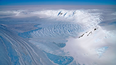
The oldest ice cores in the world have been extracted from blue ice areas like this one in Antarctica's Transantarctic Mountains. The cores are vital for better understanding Earth's early climate and refining contemporary climate models. Photograph by Chris Larsen, NASA Earth Observatory.
EOS
The oldest ice cores in the world have been extracted from blue ice areas like this one in Antarctica's Transantarctic Mountains. The cores are vital for better understanding Earth's early climate and refining contemporary climate models. Photograph by Chris Larsen, NASA Earth Observatory.
Get the Recreation.gov Mobile App
Recreation.gov

Adventure is at your fingertips with the Recreation.gov mobile app! From booking a weekend getaway to planning a cross-country road trip, the Recreation.gov app helps you find and reserve campsites, review location details for your trip, and quickly access information on past and upcoming reservations.
Recreation.gov
Adventure is at your fingertips with the Recreation.gov mobile app! From booking a weekend getaway to planning a cross-country road trip, the Recreation.gov app helps you find and reserve campsites, review location details for your trip, and quickly access information on past and upcoming reservations.
Features from the Field: Dikes and Sills
Blogs of the European Geosciences Union
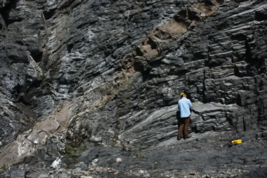
Mesozoic Lamprophyre dike crosscutting Ordovician sediments near Leading Tickles, Newfoundland, Canada. Photograph by Alexander Peace, distributed via imaggeo.egu.eu and displayed here under a Creative Commons License.
Blogs of the European Geosciences Union
Mesozoic Lamprophyre dike crosscutting Ordovician sediments near Leading Tickles, Newfoundland, Canada. Photograph by Alexander Peace, distributed via imaggeo.egu.eu and displayed here under a Creative Commons License.
Uranus's Small Moons Are Dark, Red, and Water-Poor
EOS
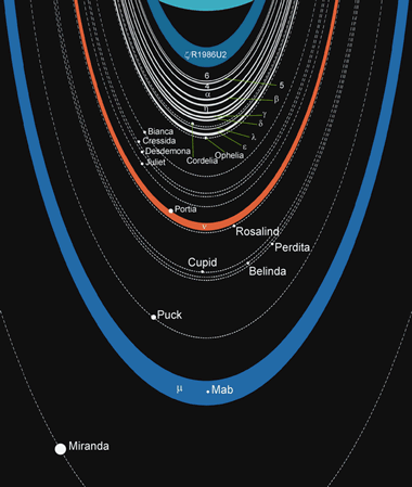
The solar system's oddball planet has some pretty odd moons. The diagram illustrates the orbital distances of Uranus's inner moons and rings. The surface of Uranus is the light blue arc at the top of the figure. Click the image to enlarge.
EOS

The solar system's oddball planet has some pretty odd moons. The diagram illustrates the orbital distances of Uranus's inner moons and rings. The surface of Uranus is the light blue arc at the top of the figure. Click the image to enlarge.
Underwater Kelp Forests are Making a Comeback in California
Smithsonian Magazine

Kelp is a large type of algae that cleans and oxygenates the water, absorbs tons of carbon dioxide, and provides a habitat for countless aquatic species. This article discusses how restoration efforts are paying off for kelp forests along the coast of California. Areas that had become barren are now seeing the return of entire ecosystems of sea creatures that live within and rely on the kelp forests. Photo by Kate Vylet / California Sea Grant, displayed here under a Creative Commons license.
Smithsonian Magazine
Kelp is a large type of algae that cleans and oxygenates the water, absorbs tons of carbon dioxide, and provides a habitat for countless aquatic species. This article discusses how restoration efforts are paying off for kelp forests along the coast of California. Areas that had become barren are now seeing the return of entire ecosystems of sea creatures that live within and rely on the kelp forests. Photo by Kate Vylet / California Sea Grant, displayed here under a Creative Commons license.
.jpg)
When Cascadia Gives Way, the San Andreas Sometimes Follows
EOS
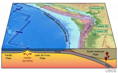
From the article: "Roughly half of the earthquakes that occurred along the southern Cascadia subduction zone over the past 3,000 years were temporally associated with earthquakes along the northern San Andreas fault." Block diagram of the Cascadia Subduction Zone by the United States Geological Survey.
EOS
From the article: "Roughly half of the earthquakes that occurred along the southern Cascadia subduction zone over the past 3,000 years were temporally associated with earthquakes along the northern San Andreas fault." Block diagram of the Cascadia Subduction Zone by the United States Geological Survey.
Sotheby's Set to Auction the Desert Rose, a 31.68-Carat Fancy Vivid Pink Diamond
JCKOnline

The Desert Rose has a rare "sunset-like" orangey hue and is estimated to be sold for between $5 million and $7 million. Photograph by Sotheby's.
JCKOnline
The Desert Rose has a rare "sunset-like" orangey hue and is estimated to be sold for between $5 million and $7 million. Photograph by Sotheby's.
All About Colored Diamonds
Geology.com

Colored diamonds are diamonds that have a noticeable bodycolor when viewed in the face-up position. Brown and yellow are the most common colors in natural colored diamonds. Diamonds with natural pink, blue, orange, green, red, and violet bodycolors are extremely rare. Images in the wonderful collection of colored diamonds shown above are used with permission of IBD Fancy Colors LLC.
Geology.com
Colored diamonds are diamonds that have a noticeable bodycolor when viewed in the face-up position. Brown and yellow are the most common colors in natural colored diamonds. Diamonds with natural pink, blue, orange, green, red, and violet bodycolors are extremely rare. Images in the wonderful collection of colored diamonds shown above are used with permission of IBD Fancy Colors LLC.